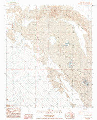
1985 Map of Cadiz Lake
USGS Topo · Published 1985About this map
Cadiz Lake and its surrounding Cadiz Valley dominate this arid landscape, which is defined by the stark industrial and natural features of the Mojave Desert in the mid-1980s. The map illustrates a specialized economy centered on salt extraction, featuring several large Salt Evaporators and associated tanks situated along the eastern margins of the dry lakebed. These industrial sites are linked by rugged 4wd tracks that cut through the extensive Cadiz Dunes and across the white expanse of the Dry Lake. The presence of numerous Prospect labels throughout the dunes and valley floor suggests a history of mineral exploration in this remote corner of San Bernardino County. The topography is meticulously detailed, showing the intricate wind-swept patterns of the sand dunes as they interface with the flat, mineral-rich basins.
Find a feature on this map
10 named features on this map. Tap any name to fly to it.
Don’t see what you’re looking for? This feature index may not catch every label — zoom into the map to look around manually.
Map Details
Editions of this 1985 Cadiz Lake Map
This is the sole edition of this map. No revisions or reprints were ever made.
Other maps of this area

1942 · Amboy
USGS Topo · 1:250,000

1943 · Amboy
USGS Topo · 1:250,000

1943 · Cadiz Lake
USGS Topo · 1:62,500

1943 · Cadiz Valley
USGS Topo · 1:62,500

1954 · Needles
USGS Topo · 1:250,000

1956 · Needles
USGS Topo · 1:250,000

1956 · Dale Lake
USGS Topo · 1:62,500

1956 · Bristol Lake
USGS Topo · 1:62,500

1956 · Cadiz Lake
USGS Topo · 1:62,500
1956 · Cadiz Valley
USGS Topo · 1:62,500