
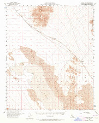
1956 Map of Cadiz Lake
USGS Topo · Published 1958About this map
Cadiz Lake and its surrounding desert basin dominate this mid-century landscape, where industrial transit and natural barriers define the human footprint. The Atchison Topeka and Santa Fe railroad cuts a diagonal path across the northern reaches, supporting the small siding at Archer and the settlement of Chubbuck. A small Cem near Archer and a remote Well indicate the sparse but permanent infrastructure required to survive in the arid Cadiz Valley. The terrain is characterized by stark elevations like the Ship Mts and Kilbeck Hills, which frame an expanse of shifting Sand Dunes. This survey captures the region just as modern Jeep Tr routes began to penetrate the deeper desert, providing a record of the early infrastructure before later developments altered the transport corridor through the Old Woman Mts.
Find a feature on this map
14 named features on this map. Tap any name to fly to it.
Don’t see what you’re looking for? This feature index may not catch every label — zoom into the map to look around manually.
Map Details
Editions of this 1956 Cadiz Lake Map
2 editions found
Other maps of this area

1942 · Amboy
USGS Topo · 1:250,000

1943 · Amboy
USGS Topo · 1:250,000

1943 · Essex
USGS Topo · 1:62,500

1943 · Danby
USGS Topo · 1:62,500

1943 · Cadiz Lake
USGS Topo · 1:62,500

1943 · Cadiz Valley
USGS Topo · 1:62,500

1943 · Iron Mountains
USGS Topo · 1:62,500

1954 · Needles
USGS Topo · 1:250,000

1956 · Needles
USGS Topo · 1:250,000

1956 · Milligan
USGS Topo · 1:62,500