
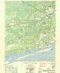
1943 Map of Calabash
USGS Topo · Published 1943About this map
Cawcaw Swamp and its various branches, including Scippio Swamp and Little Cawcaw Swamp, dominate the low-lying landscape along the border of North Carolina and South Carolina. This coastal region is defined by a series of distinct bays, such as Stanland Bay and Doghead Bay, which punctuate the dense woodlands. The rural settlement pattern is anchored by local congregations and schools, with Andrew Chapel, Beulah Ch, and La Savannah Sch serving as primary landmarks for the scattered farming community.
Find a feature on this map
44 named features on this map. Tap any name to fly to it.
Don’t see what you’re looking for? This feature index may not catch every label — zoom into the map to look around manually.
Map Details
Editions of this 1943 Calabash Map
This is the sole edition of this map. No revisions or reprints were ever made.
Other maps of this area

1943 · Little River
USGS Topo · 1:31,680

1943 · Pireway
USGS Topo · 1:31,680

1943 · Wampee
USGS Topo · 1:24,000

1943 · Freeland
USGS Topo · 1:24,000

1943 · Exum
USGS Topo · 1:24,000

1943 · Shallotte
USGS Topo · 1:24,000

1944 · Longs
USGS Topo · 1:31,680

1944 · Shallotte
USGS Topo · 1:31,680

1949 · Georgetown
USGS Topo · 1:250,000
1950 · Shallotte
USGS Topo · 1:25,000