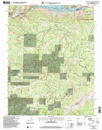
2001 Map of Calaveras Dome
USGS Topo · Published 2004About this map
Calaveras Dome and the surrounding high country define this portion of the Sierra Nevada, where the drainage of the North Fork Mokelumne River meets the northern reaches of the Stanislaus National Forest. The landscape is a network of water management and forest service operations, featuring the Salt Springs Reservoir and its associated Powerhouse and Gaging Station. Resource extraction and land management are evident through labels for the Shovel Grave Quarry and the California Div of Forestry Fire Station. The presence of Cuneo Camp and Ganns suggests the seasonal or industrial occupancy of the area. Large meadows like Mattley Meadow and St Michele Meadow provide distinct breaks in the forest canopy, while remote infrastructure like the Weather Modification Site highlights the specialized activities occurring within these public lands at the turn of the century.
Find a feature on this map
46 named features on this map. Tap any name to fly to it.
Don’t see what you’re looking for? This feature index may not catch every label — zoom into the map to look around manually.
Map Details
Editions of this 2001 Calaveras Dome Map
This is the sole edition of this map. No revisions or reprints were ever made.
Other maps of this area

1889 · Pyramid Peak
USGS Topo · 1:125,000

1891 · Big Trees
USGS Topo · 1:125,000

1891 · Pyramid Peak
USGS Topo · 1:125,000

1894 · Big Trees
USGS Topo · 1:125,000

1895 · Pyramid Peak
USGS Topo · 1:125,000

1896 · Pyramid Peak
USGS Topo · 1:125,000

1897 · Big Trees
USGS Topo · 1:125,000

1901 · Big Trees
USGS Topo · 1:125,000

1947 · Sacramento
USGS Topo · 1:250,000

1948 · Sacramento
USGS Topo · 1:250,000