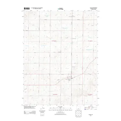
2013 Map of Calhan
USGS Topo · Published 2013About this map
Calhan serves as the central hub of this Eastern Plains landscape, where the grid of the town meets the open ranching country of El Paso County. The map provides significant genealogical value, documenting several distinct burial grounds including Saint Michaels Cem, Lenard Cem, and the National Slovak Society Cem, the latter reflecting the area's specific ethnic settlement history. The terrain is defined by the ephemeral drainage of Big Sandy Cr and its tributaries like East Br Brackett Cr, which dictate the placement of roads and reservoirs. The intersection of Us-24 and N Calhan Hwy anchors the local transportation network, while the Calhan Airport and various water management features like the Lemesany Detention Number 2 Reservoir illustrate the modern infrastructure required to support this high-plains community.
Find a feature on this map
47 named features on this map. Tap any name to fly to it.
Don’t see what you’re looking for? This feature index may not catch every label — zoom into the map to look around manually.
Map Details
Editions of this 2013 Calhan Map
This is the sole edition of this map. No revisions or reprints were ever made.
Other maps of this area

1893 · Big Springs
USGS Topo · 1:125,000

1953 · Denver
USGS Topo · 1:250,000
1954 · Haegler Ranch
USGS Topo · 1:24,000

1954 · Pueblo
USGS Topo · 1:250,000

1957 · Denver
USGS Topo · 1:250,000

1957 · Pueblo
USGS Topo · 1:250,000

1958 · Pueblo
USGS Topo · 1:250,000

1958 · Denver
USGS Topo · 1:250,000

1960 · Denver
USGS Topo · 1:250,000

1962 · Pueblo
USGS Topo · 1:250,000