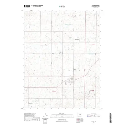
2019 Map of Calhan
USGS Topo · Published 2019About this map
Calhan serves as the central hub of this eastern El Paso County landscape, where the high plains are carved by the upper reaches of Big Sandy Cr. The town's grid, featuring streets like Golden St and Boulder St, is flanked by the Calhan Airport and the Calhan Memorial Cem. This area preserves a significant cultural footprint through its numerous burial grounds, including the National Slovak Society Cem and Saint Mary's Cem, reflecting the heritage of the local community.
Find a feature on this map
55 named features on this map. Tap any name to fly to it.
Don’t see what you’re looking for? This feature index may not catch every label — zoom into the map to look around manually.
Map Details
Editions of this 2019 Calhan Map
This is the sole edition of this map. No revisions or reprints were ever made.
Other maps of this area

1893 · Big Springs
USGS Topo · 1:125,000

1953 · Denver
USGS Topo · 1:250,000
1954 · Haegler Ranch
USGS Topo · 1:24,000

1954 · Pueblo
USGS Topo · 1:250,000

1957 · Denver
USGS Topo · 1:250,000

1957 · Pueblo
USGS Topo · 1:250,000

1958 · Pueblo
USGS Topo · 1:250,000

1958 · Denver
USGS Topo · 1:250,000

1960 · Denver
USGS Topo · 1:250,000

1962 · Pueblo
USGS Topo · 1:250,000