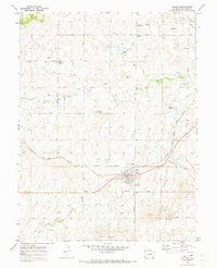
1970 Map of Calhan
USGS Topo · Published 1973About this map
Calhan serves as the primary hub of this eastern El Paso County landscape, where the Chicago Rock Island and Pacific railroad bisects the plains. The 1970 field check reveals a community anchored by tradition and local gathering points, including the County Fairground and the Fairplay Community Bldg to the northwest. Local genealogy is well-preserved through several distinct burial sites, such as St Michaels Cem and the National Slovak Society Cem, the latter reflecting the area's specific ethnic heritage. The terrain is defined by the drainage patterns of Big Sandy Creek and Brackett Creek, with the rail line following a relatively level grade across the undulating prairie. Rural life is further mapped through isolated landmarks like St Marys Ch and a network of secondary routes including Harrisville Road and West Ramah Road.
Find a feature on this map
23 named features on this map. Tap any name to fly to it.
Don’t see what you’re looking for? This feature index may not catch every label — zoom into the map to look around manually.
Map Details
Editions of this 1970 Calhan Map
This is the sole edition of this map. No revisions or reprints were ever made.
Other maps of this area

1893 · Big Springs
USGS Topo · 1:125,000

1953 · Denver
USGS Topo · 1:250,000
1954 · Haegler Ranch
USGS Topo · 1:24,000

1954 · Pueblo
USGS Topo · 1:250,000

1957 · Denver
USGS Topo · 1:250,000

1957 · Pueblo
USGS Topo · 1:250,000

1958 · Pueblo
USGS Topo · 1:250,000

1958 · Denver
USGS Topo · 1:250,000

1960 · Denver
USGS Topo · 1:250,000

1962 · Pueblo
USGS Topo · 1:250,000