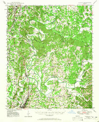
1949 Map of Calhoun
USGS Topo · Published 1965About this map
The confluence of the Conasauga River, Coosawattee River, and Oostanaula River anchors this mid-century survey of Northwest Georgia. The terrain is marked by significant cultural landmarks, including the Resaca Confederate Cem and the Cherokee Indian Memorial at Echota Village, reflecting the deep layers of indigenous and Civil War history in the region. Transportation corridors define the settlement patterns, from the Dixie Highway to the Nashville Chattanooga and St Louis railroad. Dozens of rural institutions are mapped, such as Mineral Springs Ch, Smyrna Ch, and the Hooker Sch, alongside smaller hamlets like Tilton and Resaca. The landscape transitions from the Chattahoochee National Forest in the west through the intricate river bends of the central valley toward the Red Bone Ridges.
Find a feature on this map
64 named features on this map. Tap any name to fly to it.
Don’t see what you’re looking for? This feature index may not catch every label — zoom into the map to look around manually.
Map Details
Editions of this 1949 Calhoun Map
This is the sole edition of this map. No revisions or reprints were ever made.
Other maps of this area

1886 · Dalton
USGS Topo · 1:125,000

1886 · Ringgold
USGS Topo · 1:125,000

1886 · Rome
USGS Topo · 1:125,000

1890 · Cartersville
USGS Topo · 1:125,000

1891 · Cartersville
USGS Topo · 1:125,000

1892 · Ringgold
USGS Topo · 1:125,000

1892 · Dalton
USGS Topo · 1:125,000

1896 · Cartersville
USGS Topo · 1:125,000

1897 · Dalton
USGS Topo · 1:125,000

1898 · Rome
USGS Topo · 1:125,000