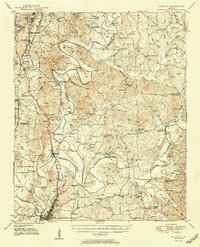
1951 Map of Calhoun
USGS Topo · Published 1951About this map
Calhoun serves as the hub of this early 1950s landscape, where the confluence of the Coosawattee River and Conasauga River forms the Oostanaula River. The geography is defined by deep historical layers, from the site of Echota Village to the 645 Cherokee Indian Memorial and the Resaca Confederate Cemetery. Transportation networks of the era are clearly visible, including the Dixie Highway and multiple rail lines like the Southern Ry and the N C & St L Ry. The map details a rural economy transitioning into the mid-century, with features such as Keiths Mill and the Dalton Airport set against the backdrop of the Chattahoochee National Forest. This survey captures the intricate local road system connecting long-standing communities like Crane Eater Corner, Angelville, and Redbud.
Find a feature on this map
120 named features on this map. Tap any name to fly to it.
Don’t see what you’re looking for? This feature index may not catch every label — zoom into the map to look around manually.
Map Details
Editions of this 1951 Calhoun Map
2 editions found
Other maps of this area

1886 · Dalton
USGS Topo · 1:125,000

1886 · Ringgold
USGS Topo · 1:125,000

1886 · Rome
USGS Topo · 1:125,000

1890 · Cartersville
USGS Topo · 1:125,000

1891 · Cartersville
USGS Topo · 1:125,000

1892 · Ringgold
USGS Topo · 1:125,000

1892 · Dalton
USGS Topo · 1:125,000

1896 · Cartersville
USGS Topo · 1:125,000

1897 · Dalton
USGS Topo · 1:125,000

1898 · Rome
USGS Topo · 1:125,000