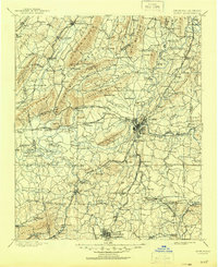
1898 Map of Rome
USGS Topo · Published 1960About this map
Rome serves as the industrial and logistical heart of this landscape, situated at the confluence where the Oostanaula River and Etowah River merge to form the Coosa River. The map, based on surveying from the late 1890s, illustrates a region defined by its reliance on water and rail transportation. Numerous river crossings like Neals Ferry, Pope Ferry, and Miller Ferry highlight the importance of river travel before modern bridging. The complex network of the Southern R.R. and the Chattanooga Rome and Southern R.R. connects mountain settlements such as Summerville and Cedartown to the larger valleys. Significant industrial landmarks, including Raccoon Mills and various mines like the Red Ore site near Fish Creek, indicate an era of active extraction and manufacturing tucked between ridges like Lavender Mountain and Johns Mountain.
Find a feature on this map
164 named features on this map. Tap any name to fly to it.
Don’t see what you’re looking for? This feature index may not catch every label — zoom into the map to look around manually.
Map Details
Editions of this 1898 Rome Map
This is the sole edition of this map. No revisions or reprints were ever made.
Historical Maps of Rome Through Time
9 maps found