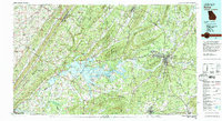
1981 Map of Rome
USGS Topo · Published 1982About this map
Rome serves as the focal point of this regional study, situated at the confluence where the Etowah River and Oostanaula River join to form the Coosa River. In the early 1980s, the landscape across the Alabama-Georgia state line is defined by the massive reservoir of Weiss Lake and a complex network of ridgelines including Lookout Mountain and Sand Mountain. The map details the educational and industrial infrastructure of the era, from the sprawling campus of Berry College and the grounds of Shorter College to the intersection of major rail lines like the Southern Railway and the Seaboard Coast Line Railroad. Further west, Gadsden and Fort Payne anchor the Alabama side, while smaller communities such as Chubbtown and Cave Spring provide insight into the rural settlement patterns of the Ridge and Valley province.
Find a feature on this map
93 named features on this map. Tap any name to fly to it.
Don’t see what you’re looking for? This feature index may not catch every label — zoom into the map to look around manually.
Map Details
Editions of this 1981 Rome Map
2 editions found
Other maps of this area

1885 · Gadsden
USGS Topo · 1:125,000

1886 · Dalton
USGS Topo · 1:125,000

1886 · Ringgold
USGS Topo · 1:125,000

1886 · Rome
USGS Topo · 1:125,000

1886 · Stevenson
USGS Topo · 1:125,000

1888 · Gadsden
USGS Topo · 1:125,000

1888 · Scottsboro
USGS Topo · 1:125,000

1889 · Tallapoosa
USGS Topo · 1:125,000

1889 · Springville
USGS Topo · 1:125,000

1890 · Cartersville
USGS Topo · 1:125,000