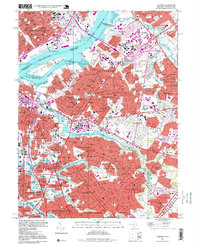
1995 Map of Camden
USGS Topo · Published 1999About this map
The Delaware River serves as the central artery for this densely developed urban corridor, connecting the industrial waterfronts of Philadelphia and Camden during the mid-1990s. The landscape is defined by its massive transportation infrastructure, including the Benjamin Franklin Bridge and Betsy Ross Bridge, which span the river to link Pennsylvania and New Jersey. On the Jersey side, the Cooper River and Cooper River Lake provide a green axis through communities like Collingswood and Haddon Heights, contrasting with the heavy rail lines of the Pennsylvania-New Jersey RR and the industrial activity near Petty Island.
Find a feature on this map
181 named features on this map. Tap any name to fly to it.
Don’t see what you’re looking for? This feature index may not catch every label — zoom into the map to look around manually.
Map Details
Editions of this 1995 Camden Map
This is the sole edition of this map. No revisions or reprints were ever made.
Other maps of this area

1888 · Mount Holly
USGS Topo · 1:62,500

1890 · Burlington
USGS Topo · 1:62,500

1891 · Philadelphia
USGS Topo · 1:62,500

1893 · Germantown
USGS Topo · 1:62,500

1893 · Burlington
USGS Topo · 1:62,500

1894 · Mount Holly
USGS Topo · 1:62,500

1894 · Philadelphia
USGS Topo · 1:62,500

1894 · Germantown
USGS Topo · 1:62,500

1896 · Germantown
USGS Topo · 1:62,500

1896 · Philadelphia
USGS Topo · 1:62,500