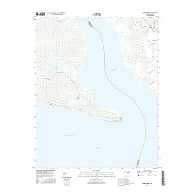
2016 Map of Camden Point
USGS Topo · Published 2016About this map
North River serves as the central artery of this coastal landscape, winding through a complex network of wetlands and marshes toward the Albemarle Sound. The map documents the intricate hydrology of the Inner Banks, where the Intracoastal Waterway navigates the channel between Camden Point and the mainland. In the northeast, the settlement of Grandy shows modern residential development with a grid of neighborhood streets including Carolina Club Dr and Uncle Graham Rd, contrasting with the wilder, marsh-dominated terrain of Great Island and Black Swamp. This survey provides a precise look at the shifting shorelines of North River Point and the vast Atlantic Ocean interface just prior to more recent coastal changes, capturing the area's essential role in North Carolina's maritime navigation and soundside geography.
Find a feature on this map
30 named features on this map. Tap any name to fly to it.
Don’t see what you’re looking for? This feature index may not catch every label — zoom into the map to look around manually.
Map Details
Editions of this 2016 Camden Point Map
This is the sole edition of this map. No revisions or reprints were ever made.
Other maps of this area

1940 · Barco
USGS Topo · 1:62,500

1940 · Powells Point
USGS Topo · 1:62,500

1940 · Wade Point
USGS Topo · 1:62,500

1943 · Wade Point
USGS Topo · 1:62,500

1946 · Eastville
USGS Topo · 1:250,000

1946 · Currituck Sound
USGS Topo · 1:250,000

1948 · Wade Point
USGS Topo · 1:62,500

1948 · Elizabeth City
USGS Topo · 1:62,500

1953 · Norfolk
USGS Topo · 1:250,000

1961 · Eastville
USGS Topo · 1:250,000