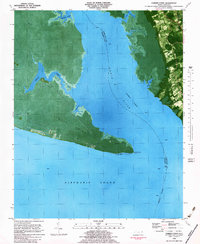
1982 Map of Camden Point
USGS Topo · Published 1983About this map
North River separates the marshy peninsulas of Camden and Currituck counties in this 1980s orthophotomap, which combines aerial imagery with topographic data. The landscape is dominated by the wedge of Camden Point, terminating at North River Point where the river meets the Albemarle Sound. This era of mapping documents the established maritime infrastructure of the Intracoastal Waterway, marked by a series of navigational lights guiding vessels through the channel. On the eastern shore, the settlement of Grandy and the developed Walnut Island reflect the residential patterns of the Currituck Sound region. Local history is preserved in the location of several Cem sites and a specific Grave near the riverbanks, alongside community hubs like Mt Zion Ch and the Cathedral of the Cross. The intricate network of tidal creeks, including Broad Creek and Lutz Cr, highlights the low-lying, water-dependent nature of this coastal environment.
Find a feature on this map
21 named features on this map. Tap any name to fly to it.
Don’t see what you’re looking for? This feature index may not catch every label — zoom into the map to look around manually.
Map Details
Editions of this 1982 Camden Point Map
This is the sole edition of this map. No revisions or reprints were ever made.
Other maps of this area

1940 · Barco
USGS Topo · 1:62,500

1940 · Powells Point
USGS Topo · 1:62,500

1940 · Wade Point
USGS Topo · 1:62,500

1943 · Wade Point
USGS Topo · 1:62,500

1946 · Eastville
USGS Topo · 1:250,000

1946 · Currituck Sound
USGS Topo · 1:250,000

1948 · Wade Point
USGS Topo · 1:62,500

1948 · Elizabeth City
USGS Topo · 1:62,500

1953 · Norfolk
USGS Topo · 1:250,000

1961 · Eastville
USGS Topo · 1:250,000