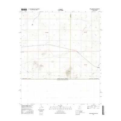
2017 Map of Camel Mountain
USGS Topo · Published 2017About this map
The international border between the United States of America and Estados Unidos Mexicanos defines the southern reach of this Chihuahuan Desert landscape. The terrain is marked by prominent volcanic and geologic formations, most notably the namesake Camel Mountain and the nearby Coyote Hill. These elevations rise above the surrounding basin floor, which includes the broad depression of Indian Basin. Human activity in this arid corridor is traced by a network of county roads, including Anapra Rd and A003 Co Rd, which navigate the sparse terrain toward the small settlement at Malpais. The map captures a high degree of cartographic detail along the boundary line separating Luna and Doña Ana counties, illustrating the intersection of natural topography and political demarcation in the Southwest.
Find a feature on this map
16 named features on this map. Tap any name to fly to it.
Don’t see what you’re looking for? This feature index may not catch every label — zoom into the map to look around manually.
Map Details
Editions of this 2017 Camel Mountain Map
This is the sole edition of this map. No revisions or reprints were ever made.
Other maps of this area

1917 · Camel Mountain
USGS Topo · 1:62,500

1917 · Mt. Riley
USGS Topo · 1:62,500

1918 · Mt. Riley
USGS Topo · 1:62,500

1929 · Mt. Riley
USGS Topo · 1:62,500

1951 · Mt. Riley
USGS Topo · 1:62,500

1953 · El Paso
USGS Topo · 1:250,000

1959 · El Paso
USGS Topo · 1:250,000

1964 · El Paso
USGS Topo · 1:250,000

1965 · El Paso
USGS Topo · 1:250,000
1965 · Camel Mountain
USGS Topo · 1:24,000