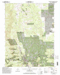
1994 Map of Cameron Mountain
USGS Topo · Published 1998About this map
San Isabel National Forest dominates this high-altitude landscape, where the convergence of Chaffee, Park, and Fremont counties defines a region of significant mineral exploration and livestock grazing. The small settlements of Whitehorn and Futurity serve as anchors for a terrain carved by numerous gulches, such as Futurity Gulch and Marble Quarry Gulch. The map reveals a high density of mining activity, with the Gold Bug Mine and dozens of unnamed prospects and quarries dotting the slopes of Calumet Mountain and Graphite Ridge.
Find a feature on this map
43 named features on this map. Tap any name to fly to it.
Don’t see what you’re looking for? This feature index may not catch every label — zoom into the map to look around manually.
Map Details
Editions of this 1994 Cameron Mountain Map
This is the sole edition of this map. No revisions or reprints were ever made.
Other maps of this area

1954 · Pueblo
USGS Topo · 1:250,000

1955 · Buena Vista
USGS Topo · 1:62,500

1956 · Cameron Mountain
USGS Topo · 1:62,500

1956 · Poncha Springs
USGS Topo · 1:62,500

1956 · Montrose
USGS Topo · 1:250,000

1957 · Pueblo
USGS Topo · 1:250,000

1958 · Pueblo
USGS Topo · 1:250,000

1959 · Montrose
USGS Topo · 1:250,000

1959 · Antero Reservoir
USGS Topo · 1:62,500

1960 · Montrose
USGS Topo · 1:250,000