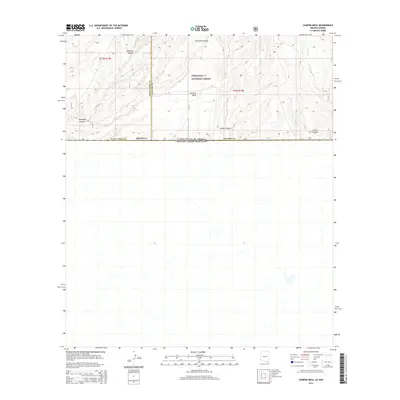
2014 Map of Campini Mesa
USGS Topo · Published 2014About this map
Coronado National Forest dominates this high-elevation terrain along the international border between the United States and Mexico. The landscape is defined by the prominent Campini Mesa, which sits nestled between several steep drainage systems. To the west, the deep incisions of Sunnyside Canyon and Blacktail Canyon reveal the complex topography of the Huachuca Mountains foothills. Moving eastward across the Cochise County line, the map tracks the headwaters of Joaquin Cr and the winding paths of School Canyon and Cave Canyon. This 2014 survey documents a rugged, largely uninhabited borderland where natural watercourses and forest service roads represent the primary human infrastructure in a landscape shaped by extreme elevation changes and drainage basins.
Find a feature on this map
11 named features on this map. Tap any name to fly to it.
Don’t see what you’re looking for? This feature index may not catch every label — zoom into the map to look around manually.
Map Details
Editions of this 2014 Campini Mesa Map
This is the sole edition of this map. No revisions or reprints were ever made.
Other maps of this area

1905 · Nogales
USGS Topo · 1:125,000

1914 · Hereford
USGS Topo · 1:125,000

1922 · Sunnyside
USGS Topo · 1:62,500

1932 · Lochiel
USGS Topo · 1:62,500

1938 · Sunnyside
USGS Topo · 1:62,500

1948 · Canelo Pass
USGS Topo · 1:24,000

1948 · Huachuca Peak
USGS Topo · 1:24,000

1948 · Miller Peak
USGS Topo · 1:24,000

1948 · Sunnyside SE
USGS Topo · 1:24,000
1948 · Sunnyside SW
USGS Topo · 1:24,000