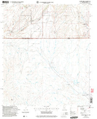
2004 Map of Campini Mesa
USGS Topo · Published 2007About this map
The international boundary between United States of America and Arizona-Sonora bisects this landscape, separating the high mesa country of the Coronado National Forest from the vast drainage basins to the south. North of the border, cattle ranching and early infrastructure define the terrain, with family-named outposts like Bercich Ranch, Sundown Ranch, and Lone Mountain Ranch scattered near Sunnyside and the local School. The topography transitions from the steep relief of Blacktail Canyon and Bodie Canyon down to the flat expanse of Llano La Bota. South of the line, the map details a network of seasonal watercourses including Arroyo el Girasol and Arroyo el Chale, leading toward small settlements such as Las Peñitas, El Durazno, and the notable Álamo Gordo (La Casona).
Find a feature on this map
48 named features on this map. Tap any name to fly to it.
Don’t see what you’re looking for? This feature index may not catch every label — zoom into the map to look around manually.
Map Details
Editions of this 2004 Campini Mesa Map
This is the sole edition of this map. No revisions or reprints were ever made.
Other maps of this area

1905 · Nogales
USGS Topo · 1:125,000

1914 · Hereford
USGS Topo · 1:125,000

1922 · Sunnyside
USGS Topo · 1:62,500

1932 · Lochiel
USGS Topo · 1:62,500

1938 · Sunnyside
USGS Topo · 1:62,500

1948 · Canelo Pass
USGS Topo · 1:24,000

1948 · Huachuca Peak
USGS Topo · 1:24,000

1948 · Miller Peak
USGS Topo · 1:24,000

1948 · Sunnyside SE
USGS Topo · 1:24,000
1948 · Sunnyside SW
USGS Topo · 1:24,000