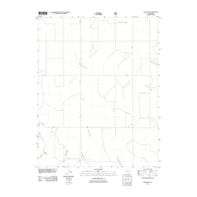
2011 Map of Campo SW
USGS Topo · Published 2011About this map
North Ute Canyon and its western branch, West Ute Canyon, define the drainage patterns of this corner of Baca County. The landscape is marked by a series of south-trending arroyos including West Squaw Canyon and East Squaw Canyon, which cut through the high plains. Human activity in this rural Colorado expanse is primarily represented by a strict grid of county roads, such as Co RD 21 and Co RD G, which navigate the plateaus between the breaks. In the southwestern corner, the Picture Canyon Picnic Area provides a designated point of interest near Arthurs Canyon and Red Canyon, where the local topography becomes more complex. This 2011 survey by the U.S. Geological Survey illustrates the intersection of natural canyon systems with the expansive agricultural road network of the High Plains.
Find a feature on this map
12 named features on this map. Tap any name to fly to it.
Don’t see what you’re looking for? This feature index may not catch every label — zoom into the map to look around manually.
Map Details
Editions of this 2011 Campo SW Map
This is the sole edition of this map. No revisions or reprints were ever made.
Other maps of this area

1891 · Springfield
USGS Topo · 1:125,000

1893 · Springfield
USGS Topo · 1:125,000

1954 · Dalhart
USGS Topo · 1:250,000

1955 · La Junta
USGS Topo · 1:250,000

1958 · La Junta
USGS Topo · 1:250,000

1958 · Dalhart
USGS Topo · 1:250,000

1962 · Dalhart
USGS Topo · 1:250,000

1968 · La Junta
USGS Topo · 1:250,000

1968 · Autograph Cliff NW
USGS Topo · 1:24,000
1969 · Kenton NE
USGS Topo · 1:24,000