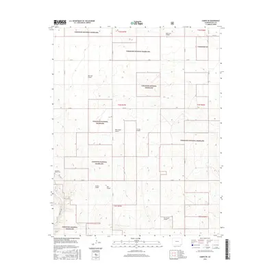
2016 Map of Campo SW
USGS Topo · Published 2016About this map
Comanche National Grassland dominates this landscape in Baca County, characterized by a series of deep drainages including Picture Canyon and North Ute Canyon. The terrain is defined by its canyon systems, where Arthurs Canyon and Red Canyon converge, and the parallel courses of West Squaw Canyon and East Squaw Canyon run southward. Human history is etched into this remote corner of Colorado at the Chadderdon - Capansky Cem, located just off Co RD 18 in the western half of the survey. The mapping reveals a sparse grid of rural routes such as Co RD J and Co RD G, which navigate the high ground between these significant natural features. For recreation and access, the Arch Rock Trail provides a dedicated path through the southwestern portion of the grassland.
Find a feature on this map
26 named features on this map. Tap any name to fly to it.
Don’t see what you’re looking for? This feature index may not catch every label — zoom into the map to look around manually.
Map Details
Editions of this 2016 Campo SW Map
This is the sole edition of this map. No revisions or reprints were ever made.
Other maps of this area

1891 · Springfield
USGS Topo · 1:125,000

1893 · Springfield
USGS Topo · 1:125,000

1954 · Dalhart
USGS Topo · 1:250,000

1955 · La Junta
USGS Topo · 1:250,000

1958 · La Junta
USGS Topo · 1:250,000

1958 · Dalhart
USGS Topo · 1:250,000

1962 · Dalhart
USGS Topo · 1:250,000

1968 · La Junta
USGS Topo · 1:250,000

1968 · Autograph Cliff NW
USGS Topo · 1:24,000
1969 · Kenton NE
USGS Topo · 1:24,000