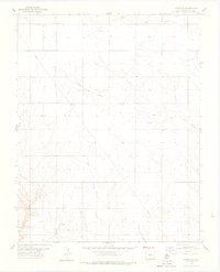
1978 Map of Campo SW
USGS Topo · Published 1978About this map
North Ute Canyon and West Ute Canyon carve through this corner of Baca County, defining a landscape dominated by drainage networks and intermittent water sources. Surveyed in the 1970s, the terrain is marked by a series of named ravines including Picture Canyon, Arthurs Canyon, and Red Canyon. Human activity in this rural expanse is concentrated around infrastructure and resource extraction, evidenced by a Pumping Sta, a Gravel Pit, and a long pipeline traversing the northern sections. Numerous wells are scattered across the quadrangle, highlighting the critical importance of groundwater for ranching or industrial operations in this arid portion of southeastern Colorado. The map meticulously records the intersection of natural topography with township and range lines, providing a clear view of land division in a region shaped by its geology and water access.
Find a feature on this map
21 named features on this map. Tap any name to fly to it.
Don’t see what you’re looking for? This feature index may not catch every label — zoom into the map to look around manually.
Map Details
Editions of this 1978 Campo SW Map
This is the sole edition of this map. No revisions or reprints were ever made.
Other maps of this area

1891 · Springfield
USGS Topo · 1:125,000

1893 · Springfield
USGS Topo · 1:125,000

1954 · Dalhart
USGS Topo · 1:250,000

1955 · La Junta
USGS Topo · 1:250,000

1958 · La Junta
USGS Topo · 1:250,000

1958 · Dalhart
USGS Topo · 1:250,000

1962 · Dalhart
USGS Topo · 1:250,000

1968 · La Junta
USGS Topo · 1:250,000

1968 · Autograph Cliff NW
USGS Topo · 1:24,000
1969 · Kenton NE
USGS Topo · 1:24,000