
1974 Map of Canada Gobernadora
USGS Topo · Published 1977About this map
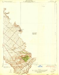
Cañada Gobernadora winds through this 1974 orthophotoquad, revealing the complex drainage patterns and canyon systems of southern Orange County. Unlike traditional line-drawn maps, this aerial perspective, produced in cooperation with the Orange County Board of Supervisors, provides a raw look at the landscape just before late-twentieth-century development altered the character of the region. The imagery highlights the sharp contrast between the deep incisions of Gabino Canyon and the surrounding ridgelines.
Find a feature on this map
3 named features on this map. Tap any name to fly to it.
Don’t see what you’re looking for? This feature index may not catch every label — zoom into the map to look around manually.
Map Details
Editions of this 1974 Canada Gobernadora Map
This is the sole edition of this map. No revisions or reprints were ever made.
Other maps of this area

1901 · Southern California Sheet No. 1
USGS Topo · 1:250,000

1901 · Elsinore
USGS Topo · 1:125,000

1901 · San Luis Rey
USGS Topo · 1:125,000

1902 · Capistrano
USGS Topo · 1:125,000

1902 · Corona
USGS Topo · 1:125,000

1904 · Southern California Sheet No. 2
USGS Topo · 1:250,000

1904 · Southern California Sheet No. 1
USGS Topo · 1:250,000

1906 · Capistrano
USGS Topo · 1:125,000
1935 · El Toro
USGS Topo · 1:31,680

1941 · Margarita Peak
USGS Topo · 1:62,500
Featured Places
- Rancho Santa Margarita, CA
- San Juan Capistrano, CA
- Coto De Caza, Coto de Caza
- San Juan Hot Springs, CA
- Coto de Caza, CA