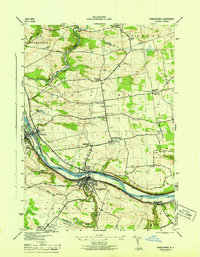
1946 Map of Canajoharie
USGS Topo · Published 1946About this map
The Mohawk River and the Barge Canal serve as the primary artery for this mid-century look at Montgomery County. Settlements like Canajoharie and Palatine Bridge are shown in detail, connected by the NYC RR and a network of local routes including the New Turnpike and York Shore Road. The landscape is dotted with rural identifiers essential for local history, from the Dillenback Cem to small schoolhouses like School No 10. The presence of the Airway Beacon near Stone Arabia reflects the integration of early aviation infrastructure into the traditional agricultural landscape. Higher elevations south of the river include Canajoharie Falls and Wintergreen Flats, where the terrain shifts away from the industrialized river valley toward the smaller drainages of Canajoharie Creek and Maple Hill Creek.
Find a feature on this map
54 named features on this map. Tap any name to fly to it.
Don’t see what you’re looking for? This feature index may not catch every label — zoom into the map to look around manually.
Map Details
Editions of this 1946 Canajoharie Map
This is the sole edition of this map. No revisions or reprints were ever made.
Other maps of this area

1896 · Fonda
USGS Topo · 1:62,500

1898 · Fonda
USGS Topo · 1:62,500

1898 · Canajoharie
USGS Topo · 1:62,500

1900 · Canajoharie
USGS Topo · 1:62,500

1901 · Lassellsville
USGS Topo · 1:62,500

1902 · Canajoharie
USGS Topo · 1:62,500

1902 · Fonda
USGS Topo · 1:62,500

1903 · Gloversville
USGS Topo · 1:62,500

1903 · Lassellsville
USGS Topo · 1:62,500

1943 · Gloversville
USGS Topo · 1:62,500