
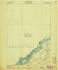
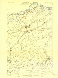
1910 Map of Canton
USGS Topo · Published 1956About this map
Canton serves as the central hub of this northern New York landscape, situated at a major crossing of the Grass River. The 1910 topography reveals a well-developed network of small settlements and rural neighborhoods, including Morley, Pyrites, and the intriguingly named Slab City. Transportation is dominated by the New York Central and Hudson River railroad, which threads through the county seat and connects it to outlying points like Eddy and Hague Crossing.
Find a feature on this map
47 named features on this map. Tap any name to fly to it.
Don’t see what you’re looking for? This feature index may not catch every label — zoom into the map to look around manually.
Map Details
Editions of this 1910 Canton Map
This is the sole edition of this map. No revisions or reprints were ever made.
Other maps of this area

1904 · Lisbon
USGS Topo · 1:48,000

1904 · Ogdensburg
USGS Topo · 1:62,500

1905 · Waddington
USGS Topo · 1:62,500

1905 · Ogdensburg
USGS Topo · 1:62,500
1906 · Red Mills
USGS Topo · 1:62,500

1906 · Massena
USGS Topo · 1:62,500
1907 · Massena
USGS Topo · 1:62,500

1908 · Potsdam
USGS Topo · 1:62,500

1911 · Canton
USGS Topo · 1:62,500

1915 · Gouverneur
USGS Topo · 1:62,500