
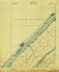
1904 Map of Ogdensburg
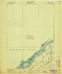
USGS Topo · Published 1957About this map
The St Lawrence River forms a massive international corridor at Ogdensburg, where the New York Central and Hudson River RR and Rutland RR converge to support a busy border economy. The landscape is defined by the winding Oswegatchie River and several smaller agricultural hubs like Heuvelton and Rensselaer Falls. Local infrastructure is well-established, with sites like the St Lawrence State Hospital occupying a significant riverside tract and rural education centers such as McCormick Schoolhouse and Bell Schoolhouse serving the outlying townships of Lisbon and Depeyster. Genealogists will find interest in localized post offices and crossroads like Kings Corners Kokomo PO and Northrup Cors, which highlight the density of early 20th-century settlement before the consolidation of rural communities. The map also traces the Rome Watertown and Ogdensburg Div, illustrating how vital rail connections were to these North Country towns.
Find a feature on this map
48 named features on this map. Tap any name to fly to it.
Don’t see what you’re looking for? This feature index may not catch every label — zoom into the map to look around manually.
Map Details
Editions of this 1904 Ogdensburg Map
This is the sole edition of this map. No revisions or reprints were ever made.
Other maps of this area

1904 · Lisbon
USGS Topo · 1:48,000

1905 · Waddington
USGS Topo · 1:62,500

1905 · Ogdensburg
USGS Topo · 1:62,500
1906 · Brier Hill
USGS Topo · 1:62,500
1906 · Red Mills
USGS Topo · 1:62,500

1910 · Canton
USGS Topo · 1:62,500

1911 · Canton
USGS Topo · 1:62,500

1912 · Hammond
USGS Topo · 1:62,500

1915 · Gouverneur
USGS Topo · 1:62,500

1915 · Russell
USGS Topo · 1:62,500