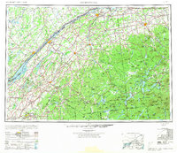
1948 Map of Ogdensburg
USGS Topo · Published 1973About this map
The St Lawrence River serves as the international boundary on this mid-century survey, dividing the bustling industrial corridors of northern New York from Ontario. In the western reaches, the industrial footprints of Massena and Ogdensburg contrast with the dense wilderness of Adirondack Park to the south and east. The map captures a transition in transit, documenting the extensive rail networks of the New York Central RR and Rutland RR alongside early state highways like NY 3 and NY 11b. In the highlands, the peaks of Whiteface Mountain and Mt Marcy tower over established resort communities at Lake Placid and Saranac Lake. Evidence of the region's extraction economy is visible through the Iron Mines and Talc Mines near Gouverneur, while the massive Pine Camp Military Reservation occupies a significant tract in the southwest corner.
Find a feature on this map
223 named features on this map. Tap any name to fly to it.
Don’t see what you’re looking for? This feature index may not catch every label — zoom into the map to look around manually.
Map Details
Editions of this 1948 Ogdensburg Map
2 editions found

Other maps of this area

1893 · Sackets Harbor
USGS Topo · 1:62,500

1895 · Sacketts Harbor
USGS Topo · 1:62,500

1895 · Mt. Marcy
USGS Topo · 1:62,500

1895 · Watertown
USGS Topo · 1:62,500

1896 · Lake Placid
USGS Topo · 1:62,500

1897 · Schroon Lake
USGS Topo · 1:62,500

1898 · Newcomb
USGS Topo · 1:62,500

1898 · Lake Placid
USGS Topo · 1:62,500

1898 · Watertown
USGS Topo · 1:62,500

1900 · Clayton
USGS Topo · 1:62,500