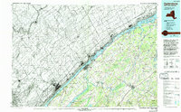
1985 Map of Ogdensburg
USGS Topo · Published 1993About this map
St Lawrence River frontage dominates this mid-1980s survey, illustrating the international border corridor where New York and Ontario meet. The map documents the industrial and institutional infrastructure of Ogdensburg, notably the St Lawrence State Hosp and the Ogdensburg International Airport. To the southwest, the distinctive narrow expanse of Black Lake is visible, while the interior of St Lawrence Co shows a mosaic of dairy-country road networks connecting rural hamlets like Heuvelton and Rensselaer Falls.
Find a feature on this map
105 named features on this map. Tap any name to fly to it.
Don’t see what you’re looking for? This feature index may not catch every label — zoom into the map to look around manually.
Map Details
Editions of this 1985 Ogdensburg Map
2 editions found
Other maps of this area

1903 · Grindstone
USGS Topo · 1:62,500

1903 · Alexandria Bay
USGS Topo · 1:62,500

1904 · Lisbon
USGS Topo · 1:48,000

1904 · Ogdensburg
USGS Topo · 1:62,500

1905 · Waddington
USGS Topo · 1:62,500

1905 · Ogdensburg
USGS Topo · 1:62,500

1906 · Brier Hill
USGS Topo · 1:62,500

1906 · Red Mills
USGS Topo · 1:62,500

1906 · Massena
USGS Topo · 1:62,500

1907 · Massena
USGS Topo · 1:62,500