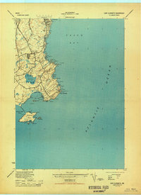
1944 Map of Cape Elizabeth
USGS Topo · Published 1944About this map
Fort Williams and the strategic heights of Portland Head overlook the entrance to Casco Bay in this mid-century coastal survey. The map details a period when maritime and military infrastructure defined the shoreline, featuring a Lighthouse, multiple Radio Towers, and a Weather Bureau Tower CG Station. These coastal defenses and navigational aids stand alongside residential developments like Delano Park and the small settlement at Pond Cove.
Find a feature on this map
68 named features on this map. Tap any name to fly to it.
Don’t see what you’re looking for? This feature index may not catch every label — zoom into the map to look around manually.
Map Details
Editions of this 1944 Cape Elizabeth Map
This is the sole edition of this map. No revisions or reprints were ever made.
Other maps of this area

1891 · Portland
USGS Topo · 1:62,500

1891 · Biddeford
USGS Topo · 1:62,500

1893 · Biddeford
USGS Topo · 1:62,500

1893 · Portland
USGS Topo · 1:62,500

1893 · Casco Bay
USGS Topo · 1:62,500

1914 · Portland
USGS Topo · 1:48,000

1914 · Casco Bay
USGS Topo · 1:48,000

1916 · Portland
USGS Topo · 1:62,500

1916 · Casco Bay
USGS Topo · 1:62,500

1916 · Portland And Vicinity
USGS Topo · 1:62,500