
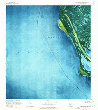
1981 Map of Cape Sable
USGS Topo · Published 1982About this map
Everglades National Park dominates this coastal landscape, where the southern tip of the Florida peninsula meets the Gulf of Mexico. The map details the intricate hydrologic network of the region, defined by the Shark River and Harney River systems which empty into the expansive Ponce De Leon Bay and Whitewater Bay. This 1981 edition is particularly notable for including offshore protraction survey data from the Bureau of Land Management, shown as a red grid over the marine areas of the Gulf and Florida Bay. On land, the three capes of Cape Sable—Northwest Cape, Middle Cape, and East Cape—frame the tidal interior, including the large Lake Ingraham. Small landmarks like Lonesome Mound and the Middle Cape Canal provide rare points of human-named reference within this wetland environment.
Find a feature on this map
34 named features on this map. Tap any name to fly to it.
Don’t see what you’re looking for? This feature index may not catch every label — zoom into the map to look around manually.
Map Details
Editions of this 1981 Cape Sable Map
This is the sole edition of this map. No revisions or reprints were ever made.
Other maps of this area

1956 · Miami
USGS Topo · 1:250,000

1958 · Miami
USGS Topo · 1:250,000

1972 · Schooner Bank
USGS Topo · 1:24,000

1972 · East Bahia Honda Key NE
USGS Topo · 1:24,000

1972 · Whitewater Bay West
USGS Topo · 1:24,000

1972 · Whitewater Bay East
USGS Topo · 1:24,000

1972 · Harney River
USGS Topo · 1:24,000

1972 · Lake Ingraham East
USGS Topo · 1:24,000
1972 · Lake Ingraham West
USGS Topo · 1:24,000

1972 · Sandy Key
USGS Topo · 1:24,000