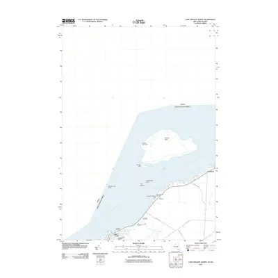
2011 Map of Cape Vincent North
USGS Topo · Published 2011About this map
Carleton Island dominates the northern reaches of the Saint Lawrence River on this international boundary survey, marking a strategic point where the river meets the open waters of Lake Ontario. This aquatic landscape is defined by its maritime navigation aids, including the Carleton Lighthouse and the Leading Light at North Bay, which guide vessels past hazards like Hinckley Flats Shoal and the Roxy Islands. Along the southern New York shoreline, the village of Cape Vincent serves as a hub for river life, supported by the Anchor Marina and the Lawrence J Docteur Marina Dock. Genealogists will find significant local history preserved at Saint Vincent de Paul Cemetery, Riverside Cemetery, and the smaller Judd Cemetery, located near the residential cluster of WillowShores.
Find a feature on this map
28 named features on this map. Tap any name to fly to it.
Don’t see what you’re looking for? This feature index may not catch every label — zoom into the map to look around manually.
Map Details
Editions of this 2011 Cape Vincent North Map
This is the sole edition of this map. No revisions or reprints were ever made.
Other maps of this area

1895 · Cape Vincent
USGS Topo · 1:62,500

1900 · Clayton
USGS Topo · 1:62,500

1903 · Grindstone
USGS Topo · 1:62,500

1903 · Clayton
USGS Topo · 1:62,500

1942 · Cape Vincent North
USGS Topo · 1:31,680

1942 · Chaumont
USGS Topo · 1:31,680

1942 · Sawmill Bay
USGS Topo · 1:31,680

1942 · Cape Vincent South
USGS Topo · 1:31,680
1943 · Grindstone
USGS Topo · 1:31,680
1944 · Cape Vincent
USGS Topo · 1:62,500