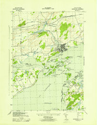
1943 Map of Grindstone
USGS Topo · Published 1943About this map
The St Lawrence River serves as the international boundary between New York and Ontario in this wartime survey, which highlights the complex archipelago of the Thousand Islands. On the American side, Grindstone Island is a focal point of rural life, featuring the settlement of Thurso with its Thurso Cem and Grindstone (PO), alongside School No 15. The Canadian shore is anchored by the industrial and transport hub of Gananoque, where the Gananoque River meets the larger waterway near the Canandian National railway at Gananoque Junction. Navigation aids like the Spectacles Shoal LH and Red Horse Rock LH point to the critical maritime traffic through the Admiralty Islands and the Bateau Channel. This map captures a landscape defined by seasonal recreation at Tremont Park and the Golf Course, balanced by the permanent farming communities of Howe Island and Cheeseborough.
Find a feature on this map
80 named features on this map. Tap any name to fly to it.
Don’t see what you’re looking for? This feature index may not catch every label — zoom into the map to look around manually.
Map Details
Editions of this 1943 Grindstone Map
This is the sole edition of this map. No revisions or reprints were ever made.
Other maps of this area

1895 · Cape Vincent
USGS Topo · 1:62,500

1900 · Clayton
USGS Topo · 1:62,500

1903 · Grindstone
USGS Topo · 1:62,500

1903 · Clayton
USGS Topo · 1:62,500

1942 · Cape Vincent North
USGS Topo · 1:31,680

1942 · Sawmill Bay
USGS Topo · 1:31,680

1942 · Clayton
USGS Topo · 1:24,000

1943 · Thousand Island Park
USGS Topo · 1:31,680

1943 · Clayton
USGS Topo · 1:31,680
1944 · Cape Vincent
USGS Topo · 1:62,500