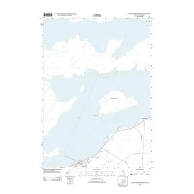
2013 Map of Cape Vincent North
USGS Topo · Published 2013About this map
Cape Vincent serves as a critical maritime gateway where the Saint Lawrence River begins its long journey from Lake Ontario. This contemporary survey details the waterfront infrastructure that defines the village's identity, including Anchor Marina and the Lawrence J Docteur Dock. The river channel is marked by the Leading Light, a necessary navigation aid for vessels traversing the waters near Carleton Island. Genealogy and local history are preserved in the community's burial grounds, such as Riverside Cem and Saint Vincent de Paul Cem, located along the roads leading out of the village center. The map also highlights the international transit link provided by the Cape Vincent-Wolfe Island Ferry, illustrating how the town remains a vital point of connection between New York and Ontario.
Find a feature on this map
28 named features on this map. Tap any name to fly to it.
Don’t see what you’re looking for? This feature index may not catch every label — zoom into the map to look around manually.
Map Details
Editions of this 2013 Cape Vincent North Map
This is the sole edition of this map. No revisions or reprints were ever made.
Other maps of this area

1895 · Cape Vincent
USGS Topo · 1:62,500

1900 · Clayton
USGS Topo · 1:62,500

1903 · Grindstone
USGS Topo · 1:62,500

1903 · Clayton
USGS Topo · 1:62,500

1942 · Cape Vincent North
USGS Topo · 1:31,680

1942 · Chaumont
USGS Topo · 1:31,680

1942 · Sawmill Bay
USGS Topo · 1:31,680

1942 · Cape Vincent South
USGS Topo · 1:31,680
1943 · Grindstone
USGS Topo · 1:31,680
1944 · Cape Vincent
USGS Topo · 1:62,500