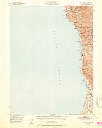
1951 Map of Cape Vizcaino
USGS Topo · Published 1951About this map
Rockport and Westport anchor this coastal segment of Mendocino County, where the steep terrain of the Coast Ranges meets the Pacific Ocean. The map reveals a landscape defined by sharp ridges and deep gulches, with Lincoln Ridge and Packard Ridge extending toward the rocky shoreline. Early industrial activity is evidenced by a Logging Road winding through the northern hills near Hardy, reflecting the region's historical reliance on timber. Small coastal settlements such as Newport, Kibesillah, and De Haven appear along the precarious coastal shelf, many situated near the mouths of creeks like Juan Creek and Wages Creek. To the south, the terrain softens slightly as the Tenmile River approaches the Tenmile River Bluff, supporting the community of Inglenook and the local Ft Bragg Grange.
Find a feature on this map
43 named features on this map. Tap any name to fly to it.
Don’t see what you’re looking for? This feature index may not catch every label — zoom into the map to look around manually.
Map Details
Editions of this 1951 Cape Vizcaino Map
2 editions found
Other maps of this area

1920 · Glenblair
USGS Topo · 1:62,500

1920 · Cummings
USGS Topo · 1:62,500

1920 · Fort Bragg
USGS Topo · 1:62,500

1921 · Westport
USGS Topo · 1:62,500

1921 · Branscomb
USGS Topo · 1:62,500

1943 · Glenblair
USGS Topo · 1:62,500

1943 · Fort Bragg
USGS Topo · 1:62,500

1950 · Piercy
USGS Topo · 1:62,500

1950 · Cape Vizcaino
USGS Topo · 1:62,500

1951 · Cape Vizcaino
USGS Topo · 1:62,500