
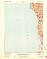
1951 Map of Cape Vizcaino
USGS Topo · Published 1951About this map
The Mendocino coast north of Fort Bragg appears here at a time when the timber and maritime economies shaped the landscape. Steep coastal bluffs and ridges, such as Cottaneva Ridge and Lincoln Ridge, dominate the shoreline, punctuated by a series of small settlements and landings that served the lumber industry. From Rockport in the north down to Westport and Inglenook, the map traces the path of early coastal transit, including a significant Logging Road winding through the hills near the Tenmile River. Genealogists and historians can locate specific community sites like the Ft Bragg Grange and several coastal cemeteries marked simply as Cem. The map documents the physical environment of these often-remote settlements, showing the proximity of landmarks like Kibesillah Hill and the rocky outcrops of Cape Vizcaino and Inner Cottaneva Rk.
Find a feature on this map
43 named features on this map. Tap any name to fly to it.
Don’t see what you’re looking for? This feature index may not catch every label — zoom into the map to look around manually.
Map Details
Editions of this 1951 Cape Vizcaino Map
2 editions found
Other maps of this area

1920 · Glenblair
USGS Topo · 1:62,500

1920 · Cummings
USGS Topo · 1:62,500

1920 · Fort Bragg
USGS Topo · 1:62,500

1921 · Westport
USGS Topo · 1:62,500

1921 · Branscomb
USGS Topo · 1:62,500

1943 · Glenblair
USGS Topo · 1:62,500

1943 · Fort Bragg
USGS Topo · 1:62,500

1950 · Piercy
USGS Topo · 1:62,500

1950 · Cape Vizcaino
USGS Topo · 1:62,500

1951 · Branscomb
USGS Topo · 1:62,500