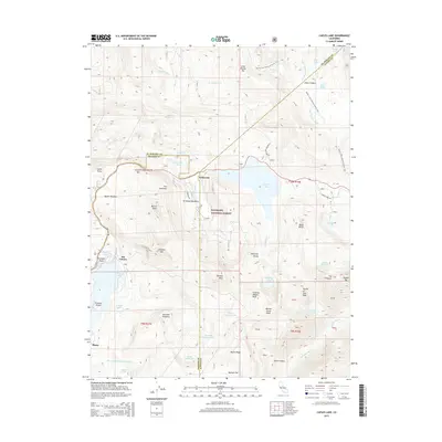
2015 Map of Caples Lake
USGS Topo · Published 2015About this map
Kirkwood and the surrounding high-elevation basins of the Eldorado National Forest are defined by sharp granite ridges and a dense network of alpine lakes. This 2015 survey captures the complex topography at the intersection of El Dorado, Amador, and Alpine counties. The landscape is a hub for high-country transit, where the Pacific Crest National Scenic Trail winds past Showers Lake and through Dixon Canyon, eventually crossing the Upper Truckee River. The map highlights significant peaks such as Thimble Peak, Melissa Coray Peak, and the iconic Round Top. Local history and geography are preserved in labels like the Machado Postpiles and the historical outpost at Plasse near the Silver Fork American River. Roads such as Schneider Cow Camp Rd and Woods Lake Rd provide access to remote trailheads and glacial basins like Emigrant Valley.
Find a feature on this map
63 named features on this map. Tap any name to fly to it.
Don’t see what you’re looking for? This feature index may not catch every label — zoom into the map to look around manually.
Map Details
Editions of this 2015 Caples Lake Map
This is the sole edition of this map. No revisions or reprints were ever made.
Other maps of this area

1889 · Pyramid Peak
USGS Topo · 1:125,000

1889 · Markleeville
USGS Topo · 1:125,000

1891 · Markleeville
USGS Topo · 1:125,000

1891 · Pyramid Peak
USGS Topo · 1:125,000

1893 · Markleeville
USGS Topo · 1:125,000

1895 · Pyramid Peak
USGS Topo · 1:125,000

1896 · Pyramid Peak
USGS Topo · 1:125,000

1947 · Sacramento
USGS Topo · 1:250,000

1948 · Walker Lake
USGS Topo · 1:250,000

1948 · Sacramento
USGS Topo · 1:250,000