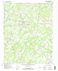
1966 Map of Capron
USGS Topo · Published 1990About this map
Capron sits at the heart of this Southampton County landscape, where the Norfolk and Western Railroad intersects with a network of rural roads and timbered wetlands. The settlement pattern is defined by several smaller communities like Newsoms, Worrell, and Angelico, each connected by routes through the surrounding swampy terrain. Extensive hydrologic features like Buckhorn Swamp, Sweat Swamp, and Tarrara Creek dominate the lowland areas, illustrating the drainage challenges faced by early settlers and farmers in this part of coastal Virginia.
Find a feature on this map
26 named features on this map. Tap any name to fly to it.
Don’t see what you’re looking for? This feature index may not catch every label — zoom into the map to look around manually.
Map Details
Editions of this 1966 Capron Map
Other maps of this area

1919 · Jarratt
USGS Topo · 1:62,500

1919 · Homeville
USGS Topo · 1:48,000

1919 · Boykins
USGS Topo · 1:48,000

1919 · Arringdale
USGS Topo · 1:48,000

1920 · Homeville
USGS Topo · 1:62,500

1920 · Boykins
USGS Topo · 1:62,500

1920 · Arringdale
USGS Topo · 1:62,500

1942 · Arringdale
USGS Topo · 1:62,500

1943 · Sebrell
USGS Topo · 1:31,680

1943 · Vicksville
USGS Topo · 1:31,680