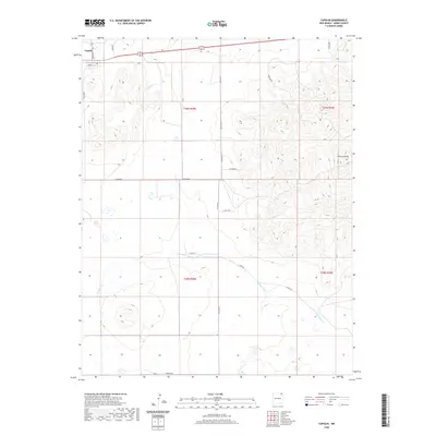
2020 Map of Capulin
USGS Topo · Published 2020About this map
The settlement of Capulin occupies the northwestern corner of this high-plains landscape in Union County, where the volcanic mass of Sierra Grande dominates the eastern horizon. The terrain is defined by a network of drainage systems and intermittent watercourses, most notably Pinabete Cr and Gallegos Cr, which carve through the volcanic landscape. A sparse but intentional grid of rural roads, such as Bison Rd and Riata Rd, provides access to the surrounding ranchlands and range. The presence of named tracks like D Bar Rd and Floyd Ln suggests the enduring layout of local land holdings and family operations. This high-altitude region reflects a late-twentieth and early-twenty-first-century reliance on managed grazing and watershed conservation across several townships, including t29n r28e and t28n r29e.
Find a feature on this map
23 named features on this map. Tap any name to fly to it.
Don’t see what you’re looking for? This feature index may not catch every label — zoom into the map to look around manually.
Map Details
Editions of this 2020 Capulin Map
This is the sole edition of this map. No revisions or reprints were ever made.
Other maps of this area

1954 · Raton
USGS Topo · 1:250,000

1954 · Dalhart
USGS Topo · 1:250,000

1958 · Raton
USGS Topo · 1:250,000

1958 · Dalhart
USGS Topo · 1:250,000

1962 · Dalhart
USGS Topo · 1:250,000

1971 · Kiowa
USGS Topo · 1:24,000

1971 · Robinson Peak
USGS Topo · 1:24,000

1971 · Palo Blanco Mountain
USGS Topo · 1:24,000

1972 · Little Grande
USGS Topo · 1:24,000
1972 · Des Moines
USGS Topo · 1:24,000