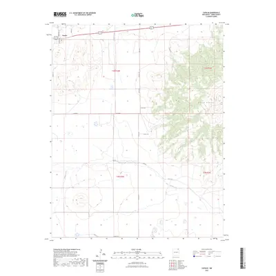
2023 Map of Capulin
USGS Topo · Published 2023About this map
Capulin stands at the northwestern corner of this high-plains landscape, where the volcanic profile of Sierra Grande dominates the eastern horizon. The settlement’s street grid is situated near the junction of Bison Rd and the shared route of 64 87, serving as a focal point for a network of rural county roads that branch into the surrounding ranch lands. The terrain is defined by the ephemeral courses of Pinabete Creek and Gallegos Creek, which weave through the townships of t29n r28e and t28n r29e. This 2023 survey illustrates a modern land-use pattern where established property lines, such as those along Kennedy Rd and D Bar Rd, follow the historical Public Land Survey System. The map documents the enduring infrastructure of Union County, showing how contemporary routes like Amistad Rd connect isolated homesteads to the primary thoroughfares crossing the plateau.
Find a feature on this map
23 named features on this map. Tap any name to fly to it.
Don’t see what you’re looking for? This feature index may not catch every label — zoom into the map to look around manually.
Map Details
Editions of this 2023 Capulin Map
This is the sole edition of this map. No revisions or reprints were ever made.
Other maps of this area

1954 · Raton
USGS Topo · 1:250,000

1954 · Dalhart
USGS Topo · 1:250,000

1958 · Raton
USGS Topo · 1:250,000

1958 · Dalhart
USGS Topo · 1:250,000

1962 · Dalhart
USGS Topo · 1:250,000

1971 · Kiowa
USGS Topo · 1:24,000

1971 · Robinson Peak
USGS Topo · 1:24,000

1971 · Palo Blanco Mountain
USGS Topo · 1:24,000

1972 · Little Grande
USGS Topo · 1:24,000
1972 · Des Moines
USGS Topo · 1:24,000