
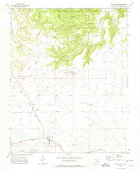
1972 Map of Capulin
USGS Topo · Published 1975About this map
Sierra Grande dominates the eastern landscape of this high-plains terrain in Union County, its volcanic slopes rising sharply above the surrounding ranching country. The settlement of Capulin sits at the northwestern edge, serving as a focal point near the historic Fort Union Road. This 1972 survey captures a rural environment where water management is critical to the local economy, evidenced by the numerous named water sources distributed across the arid sections, such as Cox Windmill and La Cueva Windmill. Drainage systems like Pinabete Creek and Gallegos Creek carve through the basin, while the presence of several Gravel Pits suggests localized mineral extraction. The network of unimproved roads and a Jeep Trail winding through the highlands reflect a landscape defined by ranching and the rugged transit routes of northern New Mexico.
Find a feature on this map
12 named features on this map. Tap any name to fly to it.
Don’t see what you’re looking for? This feature index may not catch every label — zoom into the map to look around manually.
Map Details
Editions of this 1972 Capulin Map
This is the sole edition of this map. No revisions or reprints were ever made.
Other maps of this area

1954 · Raton
USGS Topo · 1:250,000

1954 · Dalhart
USGS Topo · 1:250,000

1958 · Raton
USGS Topo · 1:250,000

1958 · Dalhart
USGS Topo · 1:250,000

1962 · Dalhart
USGS Topo · 1:250,000

1971 · Kiowa
USGS Topo · 1:24,000

1971 · Robinson Peak
USGS Topo · 1:24,000

1971 · Palo Blanco Mountain
USGS Topo · 1:24,000

1972 · Little Grande
USGS Topo · 1:24,000
1972 · Des Moines
USGS Topo · 1:24,000