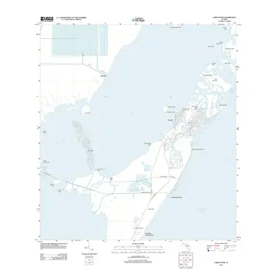
2012 Map of Card Sound
USGS Topo · Published 2012About this map
Grayvik and the northern reaches of Key Largo anchor this coastal survey, where the intricate mangroves and tidal channels of the Florida Keys meet the expanse of Card Sound. The landscape is defined by its transition from protected waters to the Atlantic Ocean, centered around the exclusive developments of the Ocean Reef Club Marina and Ocean Reef Club Airport. Navigation and land use are guided by the historic Card Sound Rd and Old Co Hwy 905, which cut through a labyrinth of small islands including Pumpkin Key, Angelfish Key, and Palo Alto Key. Along the southern shoreline, the presence of Dynamite Docks and the secluded waters of Crocodile Lake reflect the area's diverse maritime and environmental history. The map also captures the complex hydrography of the northern keys, from Jones Lagoon to the winding Steamboat Cr.
Find a feature on this map
60 named features on this map. Tap any name to fly to it.
Don’t see what you’re looking for? This feature index may not catch every label — zoom into the map to look around manually.
Map Details
Editions of this 2012 Card Sound Map
This is the sole edition of this map. No revisions or reprints were ever made.
Other maps of this area

1947 · Garden Cove
USGS Topo · 1:24,000

1947 · Blackwater Sound
USGS Topo · 1:24,000

1949 · Blackwater Sound
USGS Topo · 1:24,000

1949 · Garden Cove
USGS Topo · 1:24,000

1949 · Elliott Key
USGS Topo · 1:24,000

1949 · Card Sound
USGS Topo · 1:24,000

1949 · Pacific Reef
USGS Topo · 1:24,000

1949 · Arsenicker Keys
USGS Topo · 1:24,000

1950 · Homestead
USGS Topo · 1:24,000

1950 · Glades
USGS Topo · 1:24,000