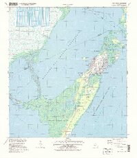
1994 Map of Card Sound
USGS Topo · Published 1998About this map
Key Largo and the surrounding island chains are depicted in this mid-1990s environmental and topographic study, highlighting the transition between intensive land use and expansive marine conservation. The landscape is defined by its intricate shoreline, where the developed enclave of the Ocean Reef Club and the settlement at Grayvik contrast with the massive tracts of the Crocodile Lake National Wildlife Refuge and John Pennekamp Coral Reef State Park. In the northern portion of the sheet, the grid-like Cooling Canals represent significant industrial infrastructure adjacent to the protected waters of the Biscayne Bay Aquatic Preserve. A network of water bodies, including Card Sound and Barnes Sound, connects the mainland to the outer keys. Notable local landmarks like Dynamite Docks, Carysfort Yacht Harbor, and several family-named points like Wednesday Point and Jew Point provide essential reference for those tracking the history of maritime navigation and recreation in the Florida Keys.
Find a feature on this map
48 named features on this map. Tap any name to fly to it.
Don’t see what you’re looking for? This feature index may not catch every label — zoom into the map to look around manually.
Map Details
Editions of this 1994 Card Sound Map
This is the sole edition of this map. No revisions or reprints were ever made.
Other maps of this area

1947 · Garden Cove
USGS Topo · 1:24,000

1947 · Blackwater Sound
USGS Topo · 1:24,000

1949 · Blackwater Sound
USGS Topo · 1:24,000

1949 · Garden Cove
USGS Topo · 1:24,000

1949 · Elliott Key
USGS Topo · 1:24,000

1949 · Card Sound
USGS Topo · 1:24,000

1949 · Pacific Reef
USGS Topo · 1:24,000

1949 · Arsenicker Keys
USGS Topo · 1:24,000

1950 · Homestead
USGS Topo · 1:24,000

1950 · Glades
USGS Topo · 1:24,000