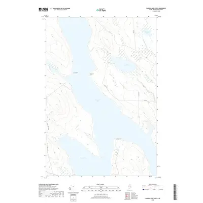
2018 Map of Caribou Lake North
USGS Topo · Published 2018About this map
Chesuncook Lake and Caribou Lake dominate this northern Maine landscape, their waters meeting at a narrow strait defined by Sandy Point and Weymouth Point. This 2018 survey reveals a remote, water-defined region where transportation is dictated by the shoreline and a network of logging roads. Named points and inlets suggest a history of navigation and seasonal encampment, while the presence of Old Hewcook Tolt Rd and Rip Rd indicates the area's continued use for timber management and backcountry access. Significant wetlands surround Mud Pond and Ripogenus Pond, connected by small tributaries like W Br Ripogenus Stream and Mud Brook. The lack of dense settlement emphasizes the wilderness character of Piscataquis County, where local landmarks are found in the terrain itself, such as Caribou Point at the southern bend of the lakeshore.
Find a feature on this map
16 named features on this map. Tap any name to fly to it.
Don’t see what you’re looking for? This feature index may not catch every label — zoom into the map to look around manually.
Map Details
Editions of this 2018 Caribou Lake North Map
This is the sole edition of this map. No revisions or reprints were ever made.
Other maps of this area

1953 · Telos Lake
USGS Topo · 1:62,500

1954 · Chesuncook
USGS Topo · 1:62,500

1954 · Grant Farm
USGS Topo · 1:62,500

1954 · Harrington Lake
USGS Topo · 1:62,500

1954 · Presque Isle
USGS Topo · 1:250,000

1954 · Millinocket
USGS Topo · 1:250,000

1957 · Telos Lake
USGS Topo · 1:62,500

1958 · Presque Isle
USGS Topo · 1:250,000

1958 · Millinocket
USGS Topo · 1:250,000

1958 · Chesuncook
USGS Topo · 1:62,500