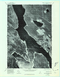
1978 Map of Caribou Lake North
USGS Topo · Published 1981About this map
Chesuncook Lake dominates this aerial perspective of the Maine wilderness, captured in the late 1970s. This orthophotograph, produced by the Geological Survey, offers a stark visual record of the northern forest and its intricate waterways. The expansive waters of Caribou Lake merge into the larger system, while smaller bodies like Mud Pond and Ripogenus Pond occupy the surrounding timberland. The imagery reveals the distinct patterns of industrial forestry, with clear-cut sections and access paths creating a geometric patchwork against the natural contours of the shoreline. This document is particularly valuable for understanding the scale of land management and the specific hydrological footprint of the region before modern digital mapping, providing an unvarnished look at the timber-and-water geography of Piscataquis County.
Find a feature on this map
4 named features on this map. Tap any name to fly to it.
Don’t see what you’re looking for? This feature index may not catch every label — zoom into the map to look around manually.
Map Details
Editions of this 1978 Caribou Lake North Map
This is the sole edition of this map. No revisions or reprints were ever made.
Other maps of this area

1953 · Telos Lake
USGS Topo · 1:62,500

1954 · Chesuncook
USGS Topo · 1:62,500

1954 · Grant Farm
USGS Topo · 1:62,500

1954 · Harrington Lake
USGS Topo · 1:62,500

1954 · Presque Isle
USGS Topo · 1:250,000

1954 · Millinocket
USGS Topo · 1:250,000

1957 · Telos Lake
USGS Topo · 1:62,500

1958 · Presque Isle
USGS Topo · 1:250,000

1958 · Millinocket
USGS Topo · 1:250,000

1958 · Chesuncook
USGS Topo · 1:62,500