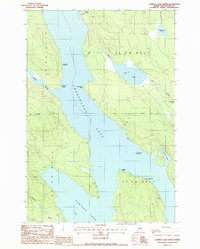
1988 Map of Caribou Lake North
USGS Topo · Published 1988About this map
Chesuncook Lake and Caribou Lake dominate this North Maine Woods landscape, joined at a narrow strait defined by Weymouth Point and Sandy Point. This 1980s survey illustrates a region shaped by timber management and remote recreation, marked by the long-standing Monument Line that bisects the townships. The map details the intricate network of water bodies that feed these large lakes, including Mud Pond and the smaller Little Mud Pond to the east. Seasonal use of the shoreline is evidenced by primitive locations like Sandy Point Campsite, Mauser Island Campsite, and Cardesa Point Campsite. Numerous drainage features like Quaker Brook, Fourmile Brook, and Red Brook carve through the townships of T 4 R 13 W E L S and T 4 R 12 W E L S, highlighting the hydraulic complexity of the Piscataquis County backcountry.
Find a feature on this map
22 named features on this map. Tap any name to fly to it.
Don’t see what you’re looking for? This feature index may not catch every label — zoom into the map to look around manually.
Map Details
Editions of this 1988 Caribou Lake North Map
This is the sole edition of this map. No revisions or reprints were ever made.
Other maps of this area

1953 · Telos Lake
USGS Topo · 1:62,500

1954 · Chesuncook
USGS Topo · 1:62,500

1954 · Grant Farm
USGS Topo · 1:62,500

1954 · Harrington Lake
USGS Topo · 1:62,500

1954 · Presque Isle
USGS Topo · 1:250,000

1954 · Millinocket
USGS Topo · 1:250,000

1957 · Telos Lake
USGS Topo · 1:62,500

1958 · Presque Isle
USGS Topo · 1:250,000

1958 · Millinocket
USGS Topo · 1:250,000

1958 · Chesuncook
USGS Topo · 1:62,500