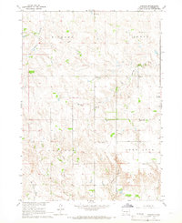
1964 Map of Carlock
USGS Topo · Published 1965About this map
The small settlement of Carlock anchors this mid-1960s landscape in southern South Dakota, where the prairie is organized into the townships of Dickens, Jones, Carlock, and Lone Star. The map reveals a high density of rural social infrastructure, including numerous educational sites like School No 38, Jeppeson Sch, and Ramis Sch. Spiritual and community life are marked by Fairmont Ch and Peace Ch, along with the Congregational Cem. This topography was surveyed as part of a broader federal effort to develop the Missouri River Basin, illustrating the intersection of natural drainage systems like Murphy Creek and Indian Creek with the section-line roads of the Great Plains. The proximity of Pleasant Hill Sch and Pleasant View Sch suggests a late-era peak in the rural schoolhouse system before regional consolidation.
Find a feature on this map
22 named features on this map. Tap any name to fly to it.
Don’t see what you’re looking for? This feature index may not catch every label — zoom into the map to look around manually.
Map Details
Editions of this 1964 Carlock Map
This is the sole edition of this map. No revisions or reprints were ever made.
Other maps of this area

1955 · Mitchell
USGS Topo · 1:250,000

1955 · O'Neill
USGS Topo · 1:250,000

1959 · O'Neill
USGS Topo · 1:250,000

1959 · Mitchell
USGS Topo · 1:250,000

1964 · Gregory SE
USGS Topo · 1:24,000

1964 · Mills
USGS Topo · 1:24,000

1964 · Gregory
USGS Topo · 1:24,000

1964 · Dallas
USGS Topo · 1:24,000

1964 · Paxton
USGS Topo · 1:24,000
1964 · Burton
USGS Topo · 1:24,000