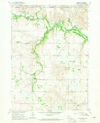
1964 Map of Burton
USGS Topo · Published 1965About this map
The Rosebud Indian Reservation Boundary defines the northern reaches of this landscape, marking the transition from the Valley and Carlock areas of South Dakota into Nebraska. The Keya Paha River meanders across the top of the map, fed by several named tributaries including Buffalo Creek and Lute Creek. These watercourses carve into the plains, creating a distinct topography that dictated the placement of early settlements and roads.
Find a feature on this map
18 named features on this map. Tap any name to fly to it.
Don’t see what you’re looking for? This feature index may not catch every label — zoom into the map to look around manually.
Map Details
Editions of this 1964 Burton Map
This is the sole edition of this map. No revisions or reprints were ever made.
Other maps of this area

1949 · Jamison SW
USGS Topo · 1:24,000

1951 · Jamison SW
USGS Topo · 1:24,000

1955 · Mitchell
USGS Topo · 1:250,000

1955 · O'Neill
USGS Topo · 1:250,000

1959 · O'Neill
USGS Topo · 1:250,000

1959 · Mitchell
USGS Topo · 1:250,000

1964 · Dallas SW
USGS Topo · 1:24,000

1964 · Mills
USGS Topo · 1:24,000
1964 · Springview
USGS Topo · 1:24,000

1964 · Paxton
USGS Topo · 1:24,000