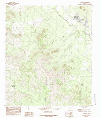
1984 Map of Carlsbad
USGS Topo · Published 1984About this map
Carlsbad serves as the primary settlement on this West Texas landscape, positioned where the North Concho River flows past the edge of the rising plateau. In the mid-1980s, the area's geography was defined by a network of drainage systems including Live Oak Creek, Sulphur Draw, and East Rocky Creek which cut through the limestone terrain. The industrial footprint of the region is evident through multiple Gravel Pits concentrated near the river corridor, while a Gaging Station on the Concho monitors the vital water levels of this arid environment. This map also delineates the jurisdictional boundary between Tom Green Co and Irion Co, showing how the rugged topography dictates the placement of roads and homesteads across the county line.
Find a feature on this map
10 named features on this map. Tap any name to fly to it.
Don’t see what you’re looking for? This feature index may not catch every label — zoom into the map to look around manually.
Map Details
Editions of this 1984 Carlsbad Map
This is the sole edition of this map. No revisions or reprints were ever made.
Other maps of this area

1895 · Sherwood
USGS Topo · 1:125,000

1924 · Sherwood 1-a
USGS Topo · 1:48,000

1928 · Tankersly
USGS Topo · 1:62,500

1954 · San Angelo
USGS Topo · 1:250,000

1957 · Carlsbad
USGS Topo · 1:62,500

1957 · Twin Buttes
USGS Topo · 1:24,000

1957 · Knickerbocker
USGS Topo · 1:62,500

1957 · Mount Nebo
USGS Topo · 1:24,000

1958 · San Angelo
USGS Topo · 1:250,000

1965 · San Angelo
USGS Topo · 1:250,000