
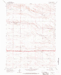
1963 Map of Carpenter
USGS Topo · Published 1967About this map
Carpenter serves as the primary hub of this high plains region, situated at the intersection of the Chicago Burlington and Quincy railroad line and local road networks. The town is marked by its grid of streets and a local Cem, providing a clear look at this agricultural community's layout in the early 1960s. The landscape is defined by the wandering path of Crow Creek, which cuts through the southern sections of the map, and the prominent state boundary of Wyoming Colorado. Numerous wells are scattered across the terrain, reflecting the vital role of water management in this prairie environment. The presence of the Laramie Co Weld Co line highlights the intersection of local jurisdictions in this borderland area where rail transport and livestock grazing shaped the local economy.
Find a feature on this map
7 named features on this map. Tap any name to fly to it.
Don’t see what you’re looking for? This feature index may not catch every label — zoom into the map to look around manually.
Map Details
Editions of this 1963 Carpenter Map
This is the sole edition of this map. No revisions or reprints were ever made.
Other maps of this area

1954 · Cheyenne
USGS Topo · 1:250,000

1954 · Greeley
USGS Topo · 1:250,000

1957 · Greeley
USGS Topo · 1:250,000

1958 · Cheyenne
USGS Topo · 1:250,000

1958 · Greeley
USGS Topo · 1:250,000

1961 · Greeley
USGS Topo · 1:250,000

1963 · Arcola
USGS Topo · 1:24,000

1963 · Burns
USGS Topo · 1:24,000

1963 · Pine Bluffs SW
USGS Topo · 1:24,000
1963 · Hillsdale
USGS Topo · 1:24,000