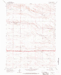
1963 Map of Hillsdale
USGS Topo · Published 1967About this map
Hillsdale sits along the vital corridor of the Union Pacific railroad in eastern Laramie County, captured here during a period of mid-century infrastructure growth. The settlement is anchored by rail facilities, including a Water Tank and a nearby Gravel Pit, reflecting the industrial requirements of the high plains transport network. To the east, the Burns Corporate Boundary marks the edge of a neighboring town, while a major subterranean Pipeline traverses the southern half of the quadrangle. The natural landscape is defined by the drainage of Lodgepole Creek to the north and the branching systems of North Fork Muddy Creek and Muddy Creek to the south. These intermittent waterways and the surrounding topography illustrate the transition from open range to a landscape increasingly partitioned by modern utilities and improved 2 Lane roadways.
Find a feature on this map
11 named features on this map. Tap any name to fly to it.
Don’t see what you’re looking for? This feature index may not catch every label — zoom into the map to look around manually.
Map Details
Editions of this 1963 Hillsdale Map
This is the sole edition of this map. No revisions or reprints were ever made.
Other maps of this area

1911 · Cheyenne
USGS Topo · 1:125,000

1914 · Cheyenne
USGS Topo · 1:125,000

1954 · Cheyenne
USGS Topo · 1:250,000

1958 · Cheyenne
USGS Topo · 1:250,000

1963 · Arcola
USGS Topo · 1:24,000

1963 · Burns
USGS Topo · 1:24,000

1963 · Pole Creek Ranch SE
USGS Topo · 1:24,000

1963 · Durham
USGS Topo · 1:24,000

1963 · Midway SE
USGS Topo · 1:24,000

1963 · Carpenter
USGS Topo · 1:24,000