
1931 Map of Carrizo
USGS Topo · Published 1938About this map
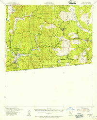
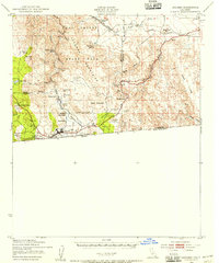
Vallecita and its nearby Vallecita Water anchor the northern reaches of this topographic study, where the Vallecita Mountains give way to the expansive Vallecita Wash. The landscape is defined by its transition from high ridges like Fish Creek Mt. to the arid depths of the Coyote Mountains. Small settlements and family holdings such as Laguna Ranch, Valdez, and Miller appear alongside indigenous sites like McCains Indians, indicating a sparse but persistent human presence in the desert interior.
Find a feature on this map
42 named features on this map. Tap any name to fly to it.
Don’t see what you’re looking for? This feature index may not catch every label — zoom into the map to look around manually.
Map Details
Editions of this 1931 Carrizo Map
This is the sole edition of this map. No revisions or reprints were ever made.
Other maps of this area

1903 · Cuyamaca
USGS Topo · 1:125,000

1903 · Ramona
USGS Topo · 1:125,000

1904 · Southern California Sheet No. 2
USGS Topo · 1:250,000

1915 · El Centro
USGS Topo · 1:125,000

1931 · Vallecito
USGS Topo · 1:125,000
1939 · Campo
USGS Topo · 1:62,500

1939 · Santa Ysabel
USGS Topo · 1:62,500

1939 · Borrego
USGS Topo · 1:62,500
1939 · Jacumba
USGS Topo · 1:62,500

1940 · Kane Spring
USGS Topo · 1:62,500